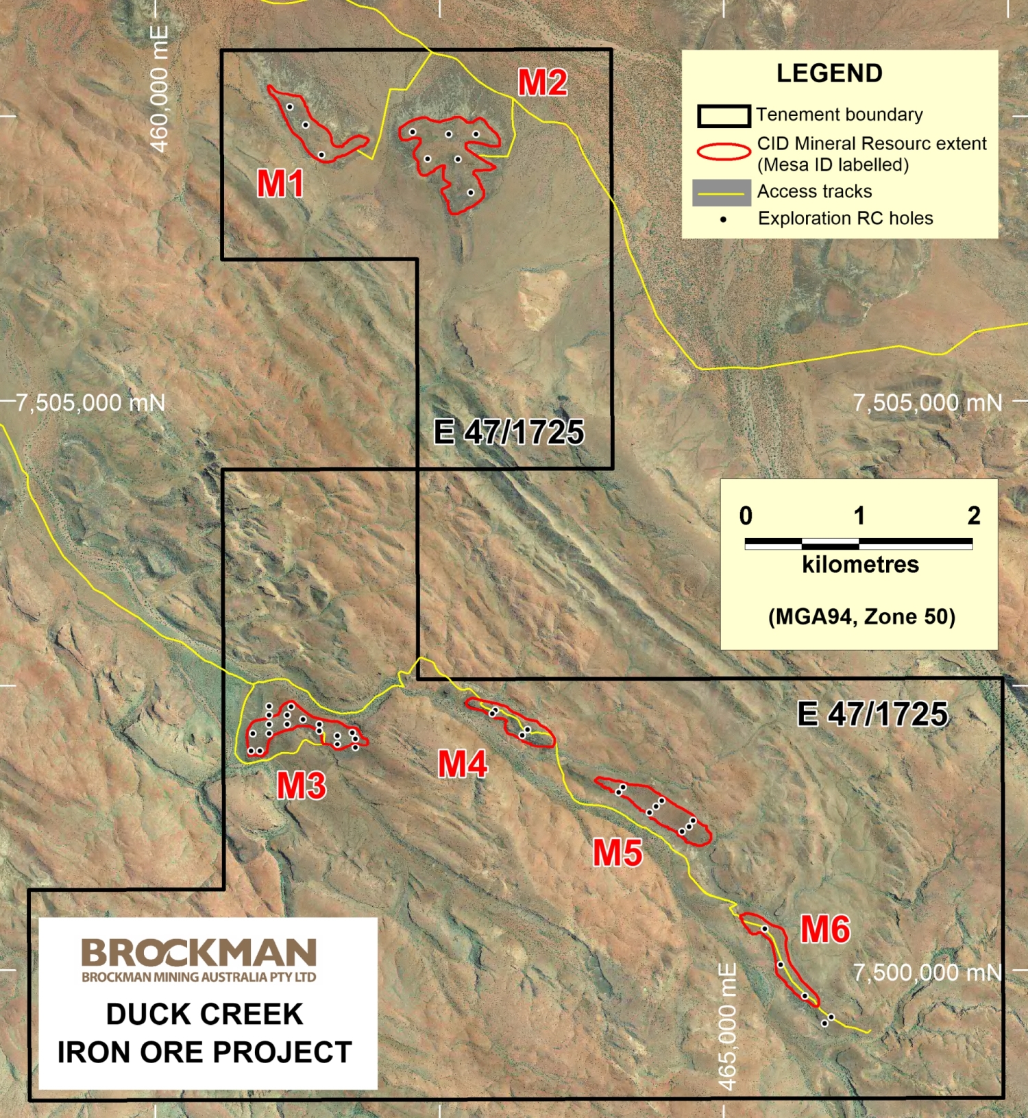
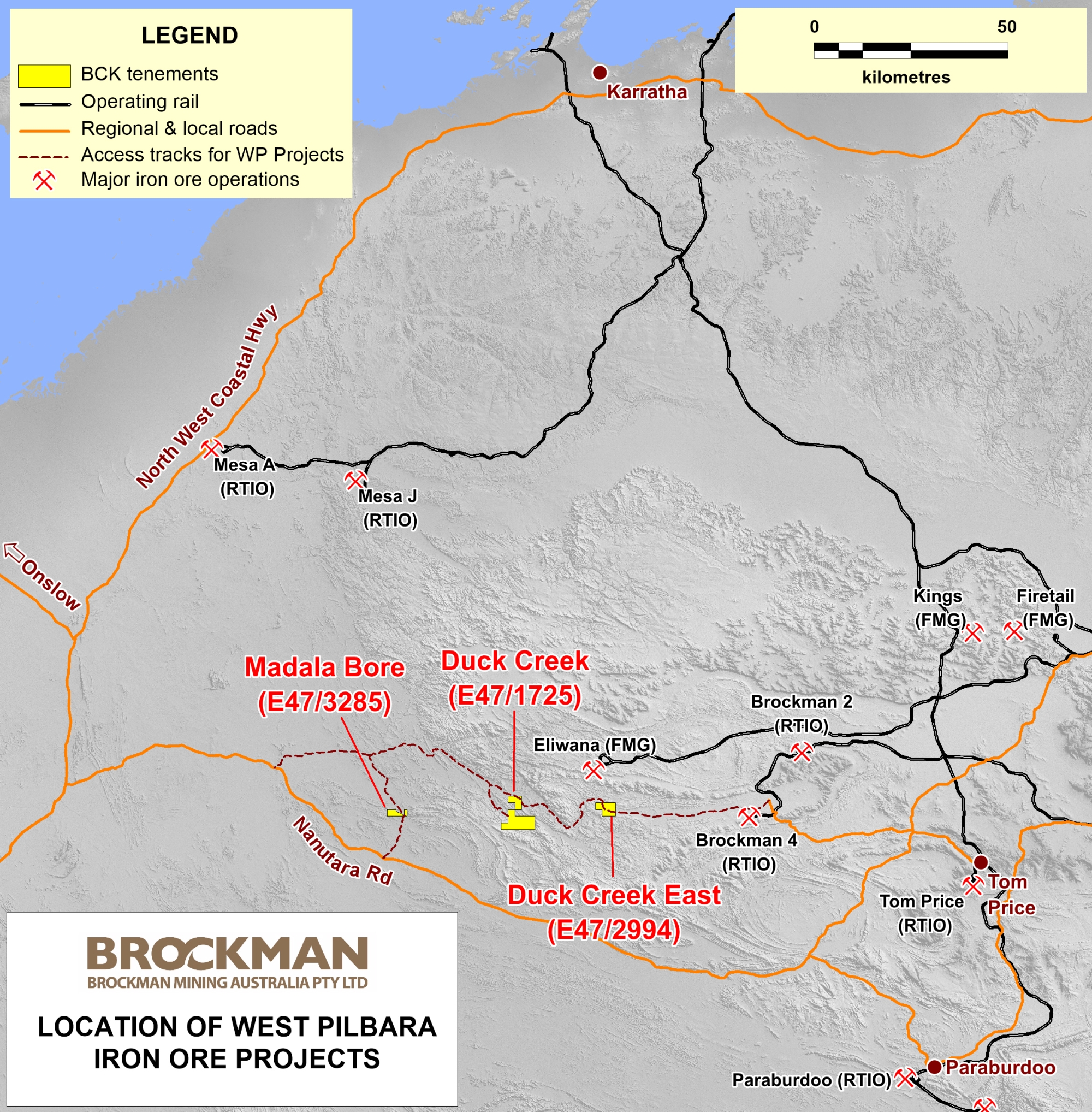
The West Pilbara Project comprises three Exploration Licences, E47/1725 (Duck Creek), E47/2994 (Duck Creek East) and E47/3285 (Madala Bore), located approximately 110-150 km northwest of the town of Paraburdoo in the West Pilbara Region. These tenements occupy a combined area of approximately 64 km2 (Figure 4).
Relative to the other two projects, the Duck Creek Project is a more advanced in exploration which included the completion of an RC drilling programme in 2010 and based on which an Inferred Iron Mineral Resource of 21.6 Mt has been estimated. It, therefore, has been the primary focus of the company’s iron ore exploration in the West Pilbara region and the subject of an ongoing assessment for potential mine development via a transhipping port near Onslow.
Duck Creek East and Madala Bore, on the other hand, are still in early exploration stage. Each of the tenements contain banded iron formations that are prospective for potential iron ore mineralisation.
At Duck Creek, the main targets for iron ore exploration are the series of CID mesas which is 15 to 30 m above the surrounding plains. Seven of these mesas have been identified to contain ore grade CID mineralisation from geological mapping and surface sampling. However, due to terrain constraints, only six of the mesas have been tested by exploration drilling so far.
An initial exploration RC drilling program conducted during late 2010, comprising 1,657 m in 45 holes, confirmed significant DSO grade mineralisation at shallow depths (often commencing at surface) in all targets drilled.
A maiden Inferred Mineral Resource of 18.3 Mt grading 56.5% Fe was estimated and reported on 15 May 2013 in compliance with JORC Code 2004. It was updated on 25 August 2020 in compliance with JORC Code 2012. Due to the use of a lower iron cut-off grade of 52% (previously 54%), the overall updated Mineral Resource increased by 3.3 Mt while the Fe grades decreased by about 0.6%. Detailed data are provided in Table 6:
| Mesa | Class | Mt | Fe (%) |
CaFe* (%) |
Al2O3 (%) |
SiO2 (%) |
P (%) |
S (%) |
LOI (%) |
|---|---|---|---|---|---|---|---|---|---|
| 1 | Inferred | 4.5 | 55.55 | 62.92 | 2.86 | 4.75 | 0.033 | 0.025 | 11.71 |
| 2 | Inferred | 7.9 | 55.56 | 62.99 | 2.97 | 4.19 | 0.037 | 0.058 | 11.79 |
| 3 | Inferred | 2.6 | 55.84 | 61.26 | 4.41 | 6.02 | 0.065 | 0.021 | 8.85 |
| 4 | Inferred | 1.5 | 55.31 | 60.86 | 3.58 | 7.42 | 0.076 | 0.015 | 9.12 |
| 5 | Inferred | 3.0 | 56.08 | 61.19 | 4.16 | 6.54 | 0.068 | 0.020 | 8.35 |
| 6 | Inferred | 2.2 | 58.17 | 62.97 | 3.22 | 4.92 | 0.106 | 0.016 | 7.62 |
| All | Inferred | 21.6 | 55.91 | 62.36 | 3.35 | 5.15 | 0.053 | 0.034 | 10.35 |
* CaFe represents calcined Fe and is calculated using the formula of Fe%/((100-LOI)/100).
As the CID Mineral Resources included in the estimation either outcrop at the surface or are under a cover of only a few meters, low stripping ratios are expected in the future mining. Mesas 1 and 2 in the north account for approximately 57% of the total Inferred Mineral Resource and are the subject of early mining conceptual mine development study due to its relatively easier access than the southern mesas and very low content of deleterious elements (phosphorous and alumina).